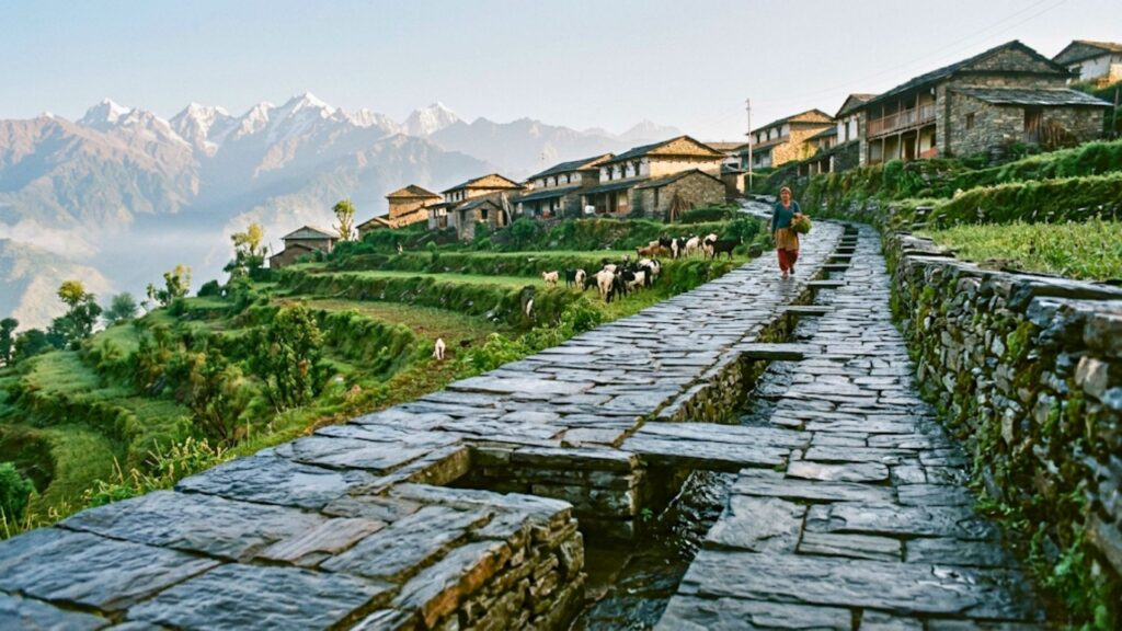
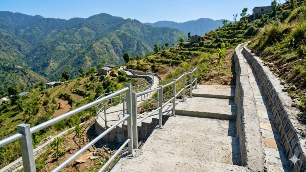
In remote Himalayan regions, the lack of all-weather footpaths, pedestrian bridges, and last-mile connectivity converts geographical remoteness into an active public safety hazard. Why last-mile access is a public safety issue becomes evident in the daily realities of these communities: it traps vulnerable populations—women, children, and the elderly—in recurring micro-crises, directly contributing to fatal medical delays, dangerous human-wildlife encounters, educational disruptions, and ultimately forced outmigration.
For decades, rural connectivity in the mountains has been viewed through a narrow macroeconomic lens: a road lowers transport costs, connects farmers to markets, and improves GDP. However, in the steep, fractured terrain of the Central Himalayas, this developmental paradigm overlooks a critical ground reality. When an unpaved village pathway crumbling down a ridge is the only link between a home and a roadhead, access ceases to be an economic luxury. It becomes the thin line between survival and preventable mortality.
This paper redefines last-mile access as a baseline parameter of public safety and constitutional equity, outlining how structural isolation actively endangers human lives in the hills.
Background and Context
The Central Himalayan ecosystem features fragile geomorphology, high seismic vulnerability, and extreme weather patterns. Rural habitations are scattered along steep ridge lines, heavily dependent on non-motorized, precarious pedestrian pathways that collapse under seasonal climate stress, turning physical isolation into a compounding structural crisis.
The topography of Uttarakhand, particularly across border districts like Pithoragarh, dictates a highly fragmented settlement pattern. Unlike plains villages that expand horizontally around a central axis, mountain hamlets are vertically distributed across varying altitudes.
The primary transportation architecture consists of two distinct components: the state-maintained motor road network and the village-level pedestrian pathways (pakhsyas and pagdandis) that span the remaining 500 meters to 5 kilometers to reach individual habitations. While policy frameworks like the Pradhan Mantri Gram Sadak Yojana (PMGSY) target vehicular connectivity to habitations above a certain population threshold, thousands of smaller, scattered settlements remain structurally isolated.
These communities depend entirely on traditional paths that are highly vulnerable to flash floods, cloudbursts, and landslides. Consequently, “remoteness” is an active, evolving threat vectors multiplied by geography.
In the steep terrain of Pithoragarh, this distance is not merely a logistical delay; it is a point of constant physical vulnerability. When an unmapped trail is the only link between a home and emergency services, infrastructure shortcomings directly impact human risk. This is why we must analyze how last-mile access operates as a critical public safety issue rather than viewing it through a standard economic development lens.
Current Situation in Uttarakhand
Uttarakhand features thousands of structurally isolated or depopulated villages facing severe climate-induced infrastructure erosion. The gap between functional motorable highways and actual household doorsteps leaves communities marooned behind unstable slopes, broken suspension bridges, and seasonal mountain torrents (gaderas).
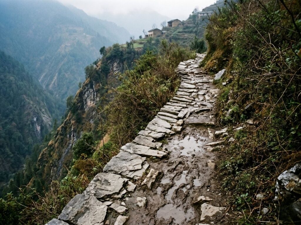
The current landscape of rural Uttarakhand is defined by a paradoxical coexistence of massive infrastructure projects and expanding internal isolation. While national highways and all-weather corridors expand along river valleys, the vertical arteries connecting these valleys to ridge-top villages are decaying.
The state’s rugged terrain experiences high rates of mass wasting, soil erosion, and cloudburst-induced structural damage. During the monsoon season, hundreds of rural paths are completely washed away, transforming small mountain streams (gaderas) into impassable torrents.
Furthermore, the lack of maintenance funds at the Gram Panchayat level means that once a stone pathway or a rustic wooden log bridge fails, it remains broken for years. This leaves residents to navigate unstable landslides and slippery cliff edges daily just to access basic necessities.
Key Challenges and Root Causes
The last-mile crisis stems from top-down infrastructure planning that ignores mountain-specific geomorphology, underfunds pedestrian-level infrastructure, and lacks decentralized maintenance models. This leaves fragmented ridge-top settlements exposed to a compounding cycle of systemic exclusion and physical danger.
       [Top-Down Urban Infrastructure Models]
                         │
                         ▼
       [Neglect of Non-Motorized/Pedestrian Paths]
                         │
                         ▼
    [Seasonal Infrastructure Erosion / Washouts]
                         │
                         ▼
   [Compounding Physical Hazard & Isolation Cascades]
The underlying factors driving this crisis are structural, financial, and topographical:
- Top-Down Infrastructure Biases: Public works departments prioritize vehicular roads, frequently classifying pedestrian steps, handrails, and small drainage crossings as low-priority “local works.” This leaves them excluded from major budgetary allocations.
- Geomorphological Fragility: The young, seismically active Himalayan range undergoes constant tectonic adjustment. Constructing heavy motor roads without scientific slope stabilization often destabilizes upper slopes, destroying the pedestrian paths situated directly above or below them.
- Settlement Fragmentation: Mountain communities are highly decentralized, consisting of small clusters (toks) separated by deep gorges or thick forests. Standard administrative metrics that allocate resources based on high population thresholds fail to support these small, isolated groups.
- The Maintenance Budget Vacuum: While state schemes fund the initial execution of rural roads, the routine maintenance of pedestrian networks is left to under-resourced Gram Panchayats. These local bodies lack the engineering expertise and financial capacity to execute long-term slope stabilization or build durable concrete pathways.
Data and Evidence
Institutional data from NITI Aayog, disaster management records, and rural development frameworks highlight a direct correlation between the length of unpaved approach paths and heightened vulnerabilities. This tracking confirms increased rates of maternal mortality during transits, lower educational retention, and accelerated outmigration.
The burden of broken pathways falls disproportionately on vulnerable groups. For an expectant mother or an isolated elder in a depopulated hamlet, a slick mud track or an unlit forest path presents immediate dangers during medical emergencies. For a comprehensive breakdown of these specific field risks and our structural mitigation strategies, read our detailed analysis on the human cost of last-mile isolation on women, children, and the elderly.
National and regional data sets underscore the tangible impacts of rural isolation:
- Healthcare Access Latency: Studies by rural health organizations indicate that in areas lacking all-weather pedestrian access, the average time required to transport a patient to a basic health facility via manual stretchers (dandi) exceeds 3.5 hours, frequently exceeding the “Golden Hour” required for emergency medical intervention.
- The Ghost Village (Bhoot Gaon) Phenomenon: Data from the Uttarakhand Migration Commission reveals a direct correlation between weak last-mile connectivity and accelerated distress migration. Villages located more than 2 kilometers away from a functional motor road experience depopulation rates over 40% higher than roadside settlements.
- Climate Vulnerability Index: According to state disaster reports, micro-landslides along unpaved village pathways account for a high percentage of localized walking injuries and fatalities during the monsoon, though these individual incidents rarely register in macroeconomic loss assessments.
Impact on Communities
The consequences of broken infrastructure are not distributed equally; they form a cascading chain of risks that disproportionately impact the structural core of rural Himalayan society.
Impact on Women
Women in remote mountain households bear the brunt of last-mile isolation. They face daily physical hazards while navigating broken trails for resource collection, alongside extreme risks during obstetric emergencies when manual transport over rough terrain is the only option.
In the wake of extensive male outmigration, women have become the primary managers of the mountain rural economy. The absence of safe, paved pathways turns routine daily activities into hazardous undertakings:
Resource Collection Hazards: Women traverse steep, unpaved trails daily while carrying heavy loads of fuel, fodder, and water. Navigating broken stone steps and slick mud tracks leads to chronic musculoskeletal trauma, severe spine compression, and frequent falls down steep slopes.
Obstetric Vulnerabilities: For pregnant women, the lack of doorstep connectivity can be life-threatening. When labor complications arise, they must be carried on improvised wooden chairs or stretchers down uneven, rocky paths in the dark. This hazardous transit increases the risks of maternal and neonatal mortality before they can even reach a roadside ambulance.
Impact on Children
Children in disconnected hamlets face severe daily hazards navigating unpaved forest trails to reach schools. These challenges cause frequent seasonal absenteeism, high dropout rates—especially among adolescent girls—and constant exposure to environmental and wildlife threats.
For children living in ridge-top toks, pursuing an education requires significant physical endurance and exposes them to daily hazards:
- Hazardous Commutes: Students frequently walk between 4 to 8 kilometers daily along narrow paths bordered by deep gorges and thick undergrowth. During the monsoon, crossing swollen streams without pedestrian bridges exposes them to the constant danger of being swept away.
- The Adolescent Drop-Out Crisis: While younger children may be accompanied by elders, adolescent girls face heightened safety risks on isolated, overgrown trails. The lack of clear visibility and secure pathways acts as a major driver of school dropouts after the primary level.
Impact on Elderly Population
The left-behind elderly population in mountain villages faces complete physical isolation due to broken pathways. This systemic disconnect cuts them off from basic healthcare services, deprives them of regular social interactions, and leaves them highly vulnerable during sudden acute medical emergencies.
As youth migrate to urban centers for work, the elderly are often left behind in depopulated villages, bearing the brunt of infrastructural neglect:
- Medical Isolation: An elderly resident suffering from chronic cardiovascular or respiratory conditions is effectively marooned if the village pathway features steep, broken, uneven steps. The physical exertion required to navigate these paths prevents them from seeking regular health checkups.
- Emergency Abandonment: During heavy winter rains or snow blocks, these individuals can face complete isolation for days. Without a smooth, low-gradient path, distributing relief supplies or evacuating an injured elder becomes nearly impossible for the few remaining neighbors.
Policy and Governance Perspective
Current rural infrastructure policies suffer from a “vehicular bias,” assessing development progress solely by road kilometers laid while ignoring pedestrian networks. Shifting this perspective requires treating last-mile pedestrian paths as vital public infrastructure subject to formal civil engineering standards.
From a policy design perspective, state planning guidelines exhibit a fundamental blind spot: they equate rural connectivity exclusively with motorable roads. If a village is linked to a PMGSY road at a distant ridge point, it is officially marked as “connected” on administrative maps. However, the internal distribution networks—the hundreds of vertical meters of footpaths connecting individual households—are omitted from institutional metrics.
This governance gap stems from a lack of standardized engineering templates for pedestrian infrastructure in hill terrains. Footpaths are built piece-meal without proper cross-drainage, retaining walls, or handrails.
To bridge this gap, policy frameworks must evolve to treat the final 500 meters of a citizen’s journey to their doorstep with the same rigorous engineering, budgetary prioritization, and safety standards applied to state highways.
The Nauladhara Perspective
Nauladhara Gram Vikas Samiti conceptualizes last-mile access as a foundational human right and a prerequisite for rural development. True mountain resilience cannot be achieved through macro-infrastructure projects alone if the path from a home to the road remains a site of regular physical risk.
At Nauladhara Gram Vikas Samiti, our grassroots operations in Khitoli village (Bin Block, Pithoragarh District) have solidified a core institutional position: you cannot build climate resilience, economic self-reliance, or dignified living systems on a broken physical foundation.
We reject the conventional development paradigm that views footpaths merely as minor village amenities. Instead, we define last-mile connectivity as a life-saving safety corridor.
If a woman cannot safely walk to her field, if a child must risk their life to reach school, or if an elder cannot be evacuated safely during a medical emergency, the community’s social structure will inevitably collapse, accelerating distress migration. Our work centers on converting precarious trails into stable, all-weather, climate-resilient pedestrian lifelines through community-led planning and engineering.
Original Framework: The Mountain Access Risk Continuum (MARC)
To enable policymakers, CSR partners, and field practitioners to objectively assess and prioritize interventions, Nauladhara has developed the Mountain Access Risk Continuum (MARC). This framework categorizes village pathways based on actual physical risk factors, shifting the focus from simple distance metrics to holistic safety outcomes.
       [ CLASS I: ESCALATED RISK ]  -->  Unpaved, No Drainage, High Slope, Heavy Wildlife Exposure
                    │
                    ▼
       [ CLASS II: MODERATE RISK ]  -->  Dry-Stone Paved, Partial Clearing, No Safety Railings
                    │
                    ▼
       [ CLASS III: SECURED PATH ]  -->  CC Paved, Active Cross-Drainage, Steel Handrails, Low Risk
The MARC Matrix
| Parameter | Class I: Escalated Risk (Active Hazard) | Class II: Moderate Risk (Unstable Transition) | Class III: Secured Path (Nauladhara Standard) |
| Surface Engineering | Unpaved mud track, exposed loose soil, high slip potential during rain. | Traditional dry-stone packing, uneven stone steps, frequent displacement. | Cement Concrete (CC) paving with anti-skid textures and interlocking steps. |
| Drainage System | None. Rainwater flows along the path, causing deep gully erosion. | Basic side cuts, prone to clogging by debris and leaf litter. | Integrated stone-lined side drains with strategic cross-drainage culverts. |
| Topographical Hazards | Adjoins sheer drops (>60° slope) without physical barriers or warnings. | Runs along moderate slopes; features sharp, unlit blind corners. | Reinforced retaining walls on valleys sides with structural anchor points. |
| Safety Infrastructure | No support. Users must rely on overhead branches or roots for balance. | Occasional wooden logs or temporary bamboo barricades. | Continuous heavy-duty galvanized iron (GI) handrails anchored in concrete. |
| Wildlife Conflict Risk | Runs through dense, unmanaged scrub; zero line-of-sight across corners. | Partially cleared margins; intermittent blind spots near seasonal streams. | Clear 3-meter shoulder visibility zones; active brush clearing along edges. |
| Vulnerable Group Safety | Complete exclusion; impassable for stretchers, children, or elderly users. | High physical strain; requires multiple assistants for emergency transit. | Universal dignity path; manageable by elderly users and safe for children. |
Practical Solutions
Mitigating last-mile hazards requires cost-effective, decentralized engineering interventions. These include building climate-resilient Cement Concrete (CC) pathways with integrated side drainage, installing continuous galvanized iron handrails along steep drops, and clearing trail shoulders to reduce wildlife encounters.
Transforming Class I and Class II paths into Class III Secured Lifelines does not require massive capital-intensive machinery. Instead, it relies on targeted, localized engineering designs tailored for fragile terrain:
- Anti-Skid Cement Concrete (CC) Paving: Replacing dirt tracks with rough-finished, high-grade concrete steps featuring a uniform riser height (not exceeding 15 cm) to reduce physical strain on the knees of elderly residents and load-bearing women.
- Integrated Cascade Drainage: Constructing continuous, stone-lined side drains parallel to the steps, paired with catch pits. This architecture directs high-velocity monsoon runoff away from the path, preventing the water from undermining the trail’s foundation.
- Galvanized Iron (GI) Safety Handrails: Anchoring industrial-grade GI pipes at least 2 feet deep into concrete bases along all valley-side edges where the slope exceeds $45^\circ$, providing vital stability for children and elders.
- Shoulder Clearance for Wildlife Mitigation: Implementing a strict 3-meter brush-clearing zone on both sides of the pathway. Removing dense bushes like Lantana improves visibility, giving residents enough time to see and avoid wildlife like leopards or wild boars.
                  [ Typical Class III Path Cross-Section ]

       Hill Side                                                    Valley Side
       ┌─────────┐
       │         │   ┌────────────────────────────────────────┐
       │ Natural │   │       Anti-Skid Concrete Steps         │
       │  Slope  │   │     (Uniform Riser ≤ 15cm Height)      │
       │         │   └────────────────────────────────────────┘
       │         │      │                                  │        ┌──────────┐
       │         │      ▼                                  ▼        │  Anchor  │
       │         │ ┌───────────┐                     ┌──────────┐   │ Concrete │
       │         │ │Stone-Lined│                     │Valleyside│   └────┬─────┘
       │         │ │Side Drain │                     │Retaining │        │
       └─────────┘ └───────────┘                     │  Wall    │   ─────┴───── Ground Level
                                                     └──────────┘
Case Examples from Himalayan Regions
Micro-level community case studies confirm that upgrading pedestrian tracks significantly reduces transit accidents, lowers seasonal school absenteeism among girls, and improves healthcare access, proving that small-scale investments can deliver substantial societal returns.
While macro-level state reports often miss these nuances, practical field implementations across the Kumaon region demonstrate clear proof of concept:
- The Khitoli Ridge Pilot: In our primary pilot geography of Khitoli village (Bin Block, Pithoragarh), initial upgrades to a steep, rocky path leading to an water source directly reduced carrying slips among local women. It also cut down on daily transit times, proving that better trail design yields direct lifestyle improvements.
- The Okhalkanda Path Rehabilitation: A comparative community intervention in Nainital district showed that installing a 1.2-kilometer continuous handrail along a steep school path cut monsoon school absenteeism by 85%. It also eliminated injuries caused by falls on slippery shale slopes, validating the focus on safety infrastructure.
Role of Community Institutions
Long-term sustainability depends on community ownership. Empowering local women-led institutions, such as Mahila Mangal Dals and Self-Help Groups (SHGs), to oversee regular maintenance guarantees swift debris clearance and trail upkeep without waiting for slow government funds.
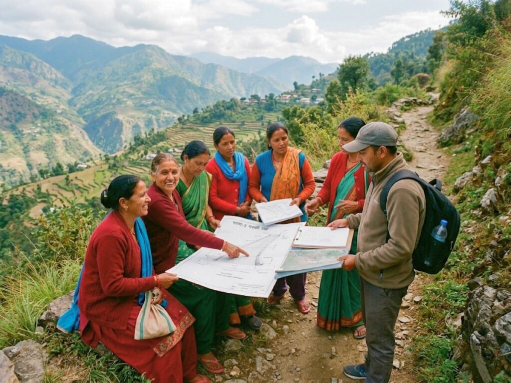
External agencies can provide engineering designs and raw materials, but long-term maintenance relies on local community ownership.
       [Nauladhara Engineering & Materials]  -->  [Mahila Mangal Dal Oversight]
                                                            │
                                                            ▼
                                              [Routine Micro-Maintenance Trajectory]
                                                            │
                                                            ▼
                                              [Perpetual All-Weather Path Security]
- Mahila Mangal Dal Partnerships: Women-led village groups are the primary stakeholders in trail safety. Entrusting them with post-monsoon clearing and path management ensures immediate, localized maintenance without administrative delays.
- Shramdaan (Community Labor) Integration: Organizing structured community workdays for tasks like clearing leaf litter, unblocking drainage channels, and cutting back roadside bushes builds local ownership. This collaborative effort helps protect the infrastructure from future seasonal damage.
Future Outlook
As climate change intensifies mountain weather patterns, the risk of infrastructure failures will grow. Future rural development strategies must integrate climate-resilient pedestrian paths into regional master plans to protect isolated communities from becoming permanently stranded.
As climate change shifts weather patterns across the Himalayas—bringing intense, short-duration rainfall and extended droughts—the structural integrity of unpaved hill paths will face greater stress. If these lifelines are left unmanaged, rural communities risk total isolation.
Future planning models must move past reactive disaster relief. Instead, they should invest in proactive, climate-hardened pedestrian networks, positioning last-mile safety as a core pillar of state climate adaptation planning.
Conclusion
Last-mile access is a fundamental matter of public safety, bodily integrity, and basic human rights. Ensuring safe connectivity for vulnerable mountain communities requires immediate cooperation between grassroots organizations, corporate CSR programs, and state planning bodies.
The isolation of remote Himalayan villages cannot be dismissed as an unavoidable geographical reality. Every injury on an unpaved slope, every delayed medical transport, and every school dropout caused by a hazardous trail points to an infrastructure design flaw.
By reframing the last-mile access issue from a standard economic metric to an immediate public safety priority, we can deploy targeted, low-cost engineering interventions to protect lives. Nauladhara Gram Vikas Samiti remains committed to scaling this model across Pithoragarh and the wider Kumaon region, ensuring that mountain living is defined by safety, dignity, and opportunity.
FAQ Section
Why should corporate CSR programs fund pedestrian footpaths instead of vehicular roads?
Vehicular roads require massive capital allocations and heavy machinery, which fall under the domain of state departments. Corporate CSR funds can achieve high social impact by investing in pedestrian networks—the final 500 meters to doorsteps—where relatively small investments can quickly eliminate safety hazards for women, children, and elders.
How does improving a village footpath help reduce distress migration?
Distress migration from hill villages is often driven by cumulative micro-crises: the daily strain of carrying loads over broken paths, fear for children’s safety on the way to school, and delayed medical access. Securing these pathways removes these daily stressors, making village life safer and more sustainable.
How do anti-skid concrete pathways hold up against freezing winters and heavy monsoons?
Nauladhara recommends using high-grade concrete mixes with deep grooved patterns for drainage, built on stone foundations with regular weep holes. This design prevents water from pooling and freezing, reducing surface cracking and maintaining traction during heavy rains.
What role do local women play in planning these pathways?
Women are the primary users of these trails for collecting water, fodder, and firewood. Nauladhara works directly with Mahila Mangal Dals to map out high-risk zones, determine correct step heights, and plan optimal alignments before pouring any concrete.
Can these path designs withstand landslides?
While heavy landslides can damage any structure, our Class III designs incorporate valley-side retaining walls and flexible drainage channels. These features help channel surface runoff away from the trail, preventing soil saturation and reducing the risk of localized path washouts.
How does pathway clearing help reduce human-wildlife conflict?
Predators like leopards often utilize thick roadside bushes, such as Lantana, for cover near village trails. Clearing a 3-meter shoulder along the pathway eliminates these hiding spots, providing residents with clear visibility and reducing the likelihood of sudden encounters.
How are these projects managed when the NGO leadership is away from the field?
Nauladhara uses a decentralized remote management system. We establish clear Standard Operating Procedures (SOPs) and partner with local village management committees. This structure allows resident field coordinators to manage daily construction and maintenance independently.
How can a Gram Panchayat get funding for these safety pathways?
Panchayats can combine funds from the Mahatma Gandhi National Rural Employment Guarantee Act (MGNREGA) for basic labor with corporate CSR support or state grants to purchase specialized materials like cement, gravel, and steel handrails.